
USA: NOAA Marine Charts & Lake Maps
by Gps Nautical Charts
Version 5,000+ 💾 24 Mb
📅 Updated Eligible if bought after 7/2/2016.
Learn
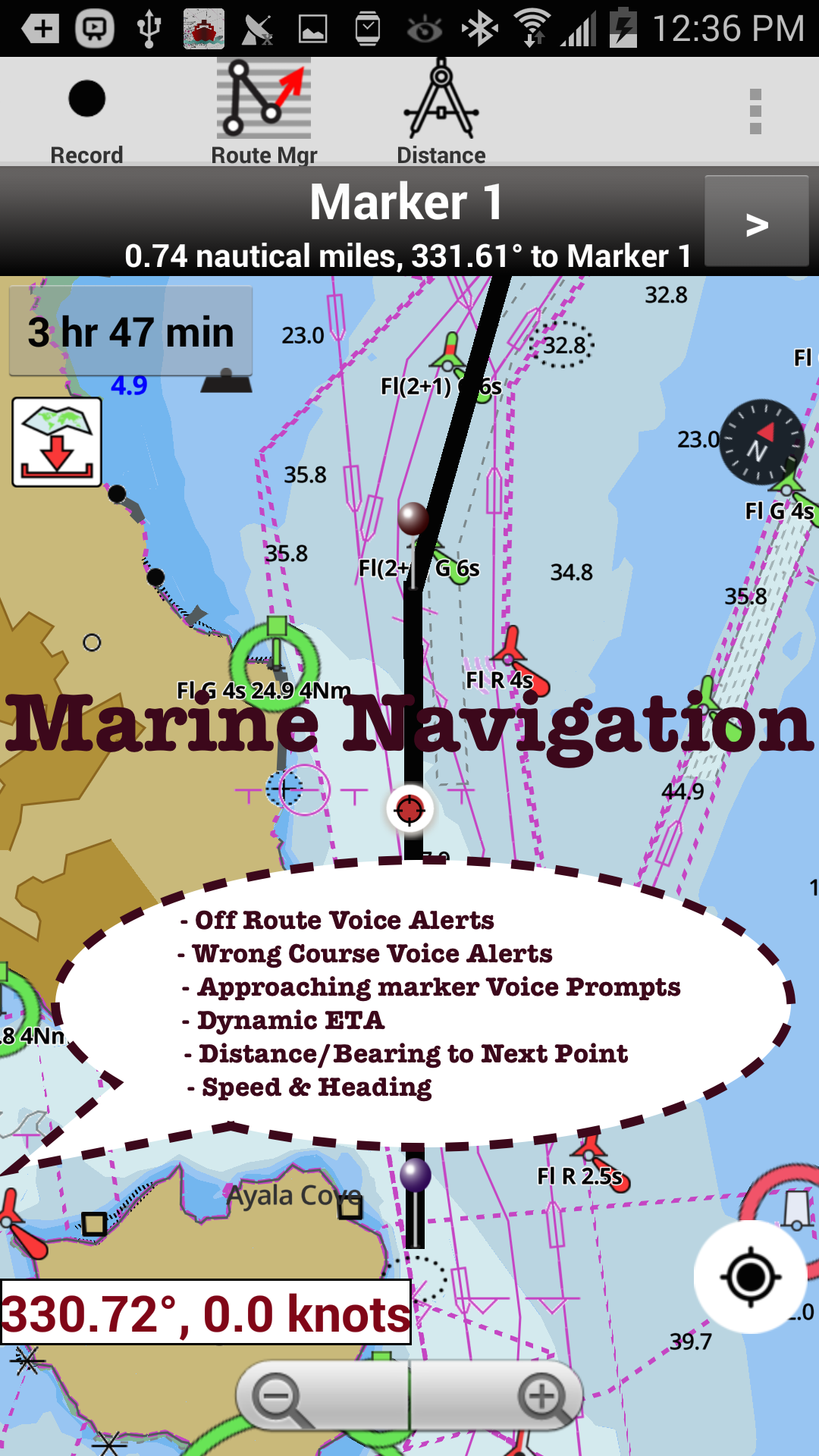
Marine navigation & Route assistance with Voice Prompts - Never get lost again!!
Features USA: NOAA Marine Charts & Lake Maps
Marine Navigation / Charts App offers access to NOAA, USACE ENC nautical charts, lake depth maps & inland river navigation charts.
Boating GPS app includes Marine Charts with course up orientation, marine weather data (Tide & Currents).
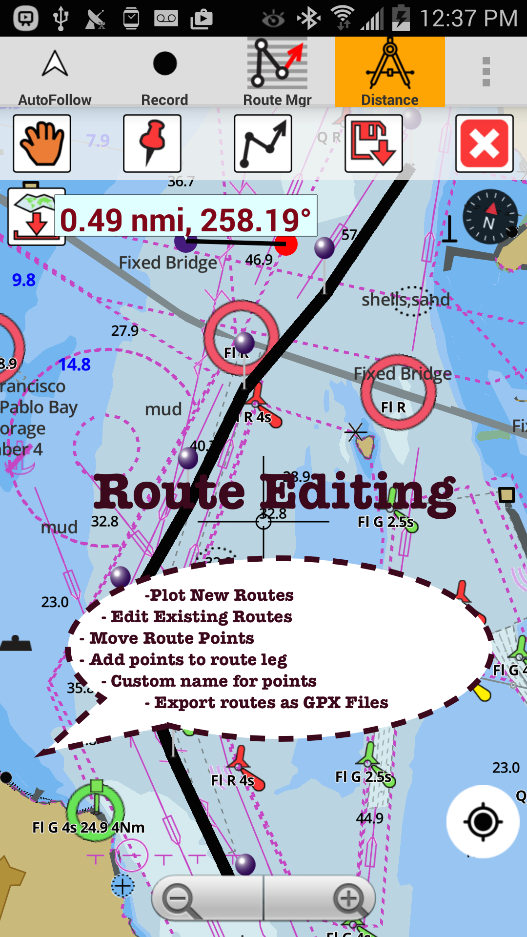
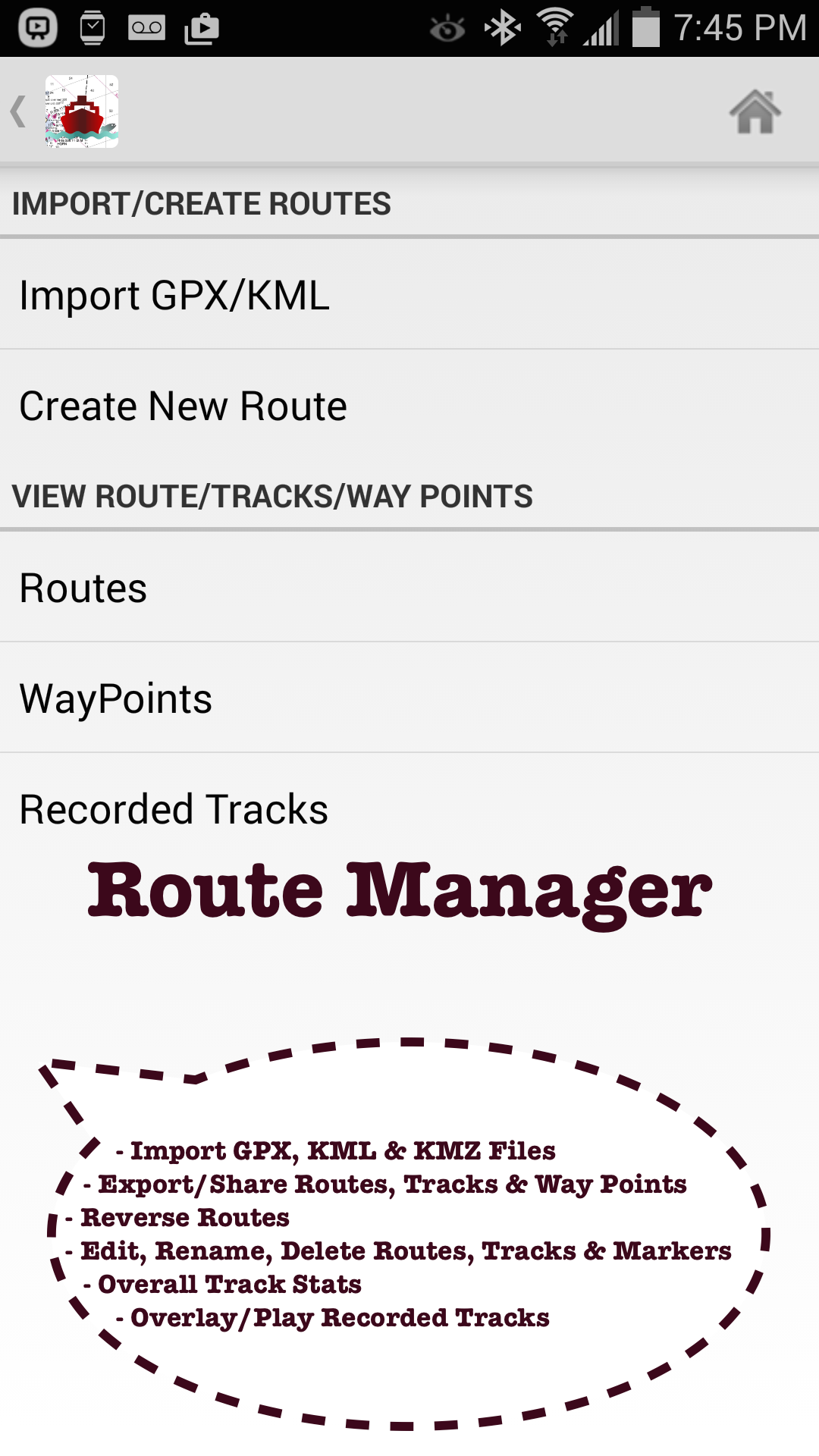
Create new boating GPS routes /Fishing Spots or import existing GPX/KML routes.
Only marine chartplotter app to have route assistance with Voice Prompts for marine navigation.►FEATURES√ Offline vector marine charts (text stays upright on rotation)√ Query details of Maritime Aids to Boat Navigation (Buoy,Lights,Obstruction,Marina etc)√ Custom depth shading of safety depth & units(Ft/Fathom/Meter/km/mi/NM)√ Record marine GPS tracks,Autofollow with real-time track overlay√ Voice Prompts for marine navigation (needs GPS )√ 1ft / 3ft depth contour maps for anglers for selected lake maps.Useful for fishing/trolling(freshwater/saltwater).√ GPX/KML for boat GPS route mgt.√ Tide & Currents.√ Seamless marine chart quilting: Map details from Coastal,Approaches,Harbour,Inland Encs(rivers)& general ENC (Electronic Marine Charts) √ Waypoints support.►FreshWater Fishing Lake maps: - Lake depth charts,boat ramps,HD depth contour maps,fishing hot spots,fish attractor locations,add fishing spots.►Instrumentation√ Marine AIS & (NMEA AIS & GPS over TCP/UDP)√ Wind direction & Speed,Sonar depth,Water temperature►Boat Navigation Voice Alerts -Alerts when sailing/boating off route or when boating wrong direction.Continuously distance & ETA updates with boating route marker prompts.►ROUTE MANAGEMENT / TRIP PLANNING√ Create/Edit/Reverse Boat Routes√ Waypoints mgt√ Import GPX,KML & KMZ files√ Share/Export Routes,Fishing Spots,Tracks&Markers► Tide & Currents -High / Low tides,Tidal Currents,Active currents stations.►Custom Background Map√ Satellite imagery,street maps,topo maps & more►GPS FEATURES for BOAT NAVIGATION√ Auto Follow*Real Time Overlay & Predicted Path Vector*Course Up*Speed & Heading (SOG & COG)►NOAA Charts for Marine Navigation√ Florida Marine Navigation ChartsCHARLOTTE HARBOR TO TAMPA BAY, KEY WESTMIAMI, EVERGLADES HARBOR√ Maryland Nautical Charts√ Virgina Marine Charts√ California Lakes & Marine ChartsSAN FRANCISCO BAY TO ANTIOCH COYOTE PT HARBORCATALINA HARBORSAN DIEGO BAYLake Tahoe√ Washington Marine ChartsSEATTLE HARBOR ELLIOTT BAY AND DUWAMISH WATERWAYTACOMA HARBORSNAKE RIVER LAKE BRYANPUGET SOUND√ Texas Marine ChartsDRUM BAY TO GALVESTON BAYGULF OF MEXICOMISSISSIPPI RIVER TO GALVESTONCORPUS CRISTI BAY PORT ARANSAS TO PORT INGLESIDE√ Louisiana Marine Charts√ Hawaii sailing chartsISLAND OF OAHUHONOLULU HARBORISLAND OF KAUAI√ Alaska FishingBERING STRAIT NORTHYAKUTAT HARBOR√ Great Lakes: Lake Michigan,Huron,Ontario,Superior,Erie√ Michigan Marine ChartsDETROIT RIVERLAKE SAINT CLAIR√ Illinois Marine ChartsCHICAGO HARBORFox Chain O Lakes√ Wisconsin Marine ChartsLAKE WINNEBAGO AND FOX RIVERMILWAUKEE HARBOR WISCONSINLake KentuckyMark Twain,Ozarks,Table Rock►Minnesota lakes: Red lake,Kabetogama,Minnetonka,Waconia,Leech,Mille Lacs►Texas Fishing : Lake Texoma,Eufaula,Toledo Bend►Florida Fishing: Lake Okeechobee,Kissimmee►Massachussets lakes Quabbin► Ohio Fishing maps of Lake hoover►Wisconsin Fishing: Lake Winnebago,Pepin► Utah Lake Powell,Bear► Maine Lake Sebago► Alaska Fishing: Lake Winnipesaukee►Tennessee Lake Barkley,Norris,Watts Bar►South Carolina Lake Keowee,Hartwell,Murray,Jocassee,Greenwood,- Satellite imagery, street maps & topos as baseman-Advanced NMEA Instrumentation- AIS over TCP/UDP- Wind Direction, Wind Speed, GPS Temperature, Sonar Depth over NMEA- Real time track overlay- Voice prompts for marine navigation- Nautical Charts Course up- Route Manager- Tide & Currents- Option to keep screen on during navigation- Display Boats speed- Inland rivers data published by USACE-Minnesota lakes HD(1ft)- Kabetogama, Minnetonka, Waconia,Leech,Mille Lacs etc.
Secure & Private
Your data is protected with industry-leading security protocols.
24/7 Support
Our dedicated support team is always ready to help you.
Personalization
Customize the app to match your preferences and workflow.
See the USA: NOAA Marine Charts & Lake Maps in Action

What Our Users Say
Don't just take our word for it. Here's what our users have to say about our Android app.
"Not worth the money"
Clint Baker
"Worked great when boat gps back light died at night. Could not see where we were. Got us back to MDR in the fog."
Stephen Speregen
"DO NOT BUY!!!!!!! i purchased this app about a year ago for $20. pulled my tablet out of the boat today to get it ready for the spring the app will not work without an update and you have to purchase the update. they disabled most of the features on the old version so it's basically useless total BS. i talked to a friend of mine he had the same problem"
carl koehler
"It's a great app, the maps are very detailed. Be sure to know at least a little about marine rules before hand."
Steve Drake
"Don't know what to think about this app. I paid for it, but now I can't download/purchase charts."
Axel Gruel
"Mot too bad could have more info"
James Hartman
"everything one needs to navigate"
Geoffroy Birtz
"Awesome App! Works great! Very convenient and accurate!"
James Latousek
"Only used twice,but it worked well"
Sidney Lopatin
"It seems to freeze a lot while in use. I had to buy the app for a second time because it said I did not have the pro. Very irritating."
Sharon Ray-Cassedy
Get the App Today
Available for Android 8.0 and above